Field Notes / Field Triangulate – Currently Free

I wrote these mainly for my own use, but took the time to productize them, so charge for them. That said, I like them being used and doing good, so if their price is a barrier, here is an opportunity to try them for free…

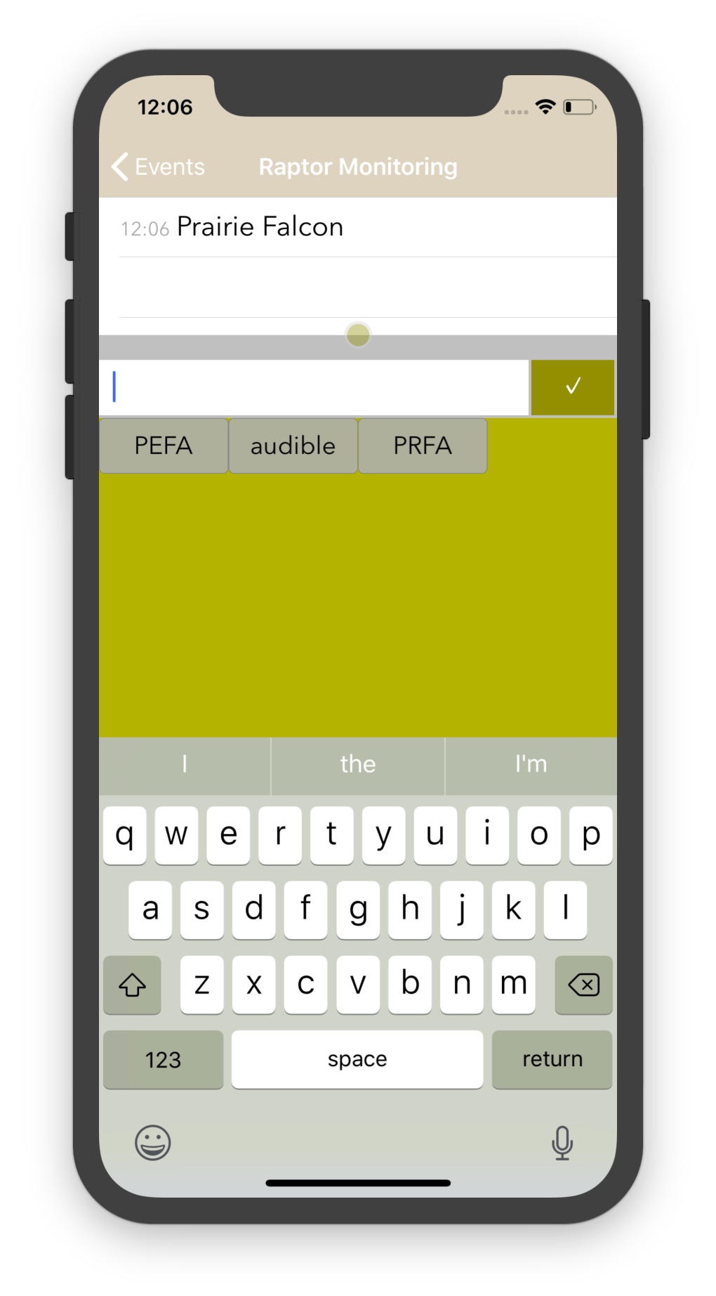
Timestamped Field Notes:

I use this myself for Raptor Monitoring taking timestamped notes when trying to keep binoculars on Peregrine Falcons, Prairie Falcons and Golden Eagles. Some use ethograms with primates, spiders, and more. It has been used for observation notes for everything from humans to whales and many more. Some use it for taking health log notes. The application is iOS only, but it is free for the month: 

https://www.neukadye.com/mobile-applications/timestamped-field-notes/

Since this application is iOS only, I made Notes Collector free for the week on Android:

https://www.neukadye.com/mobile-applications/notes-collector/
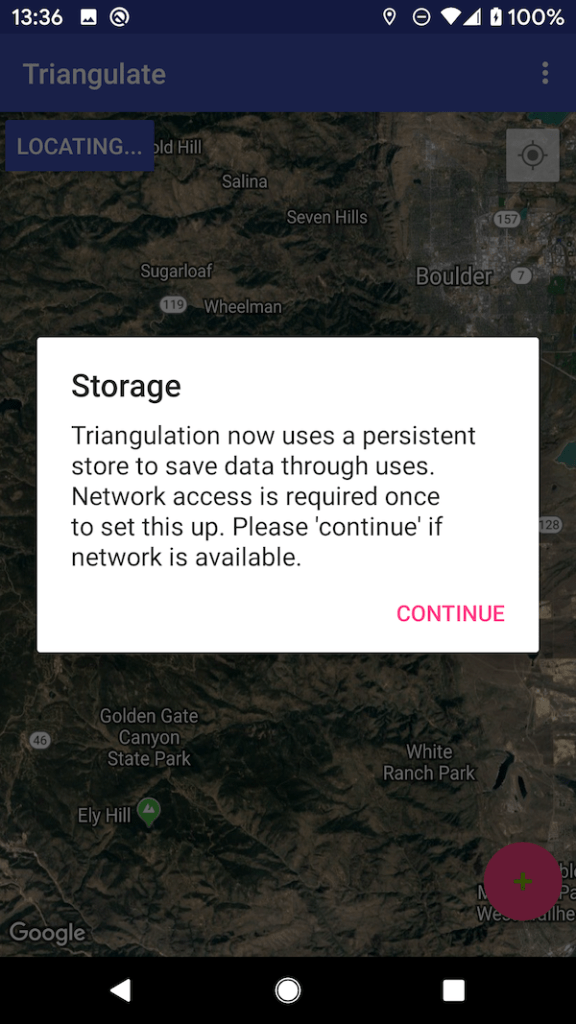
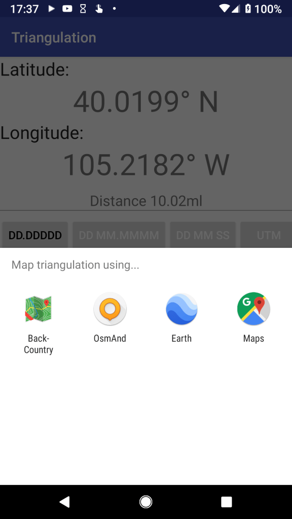
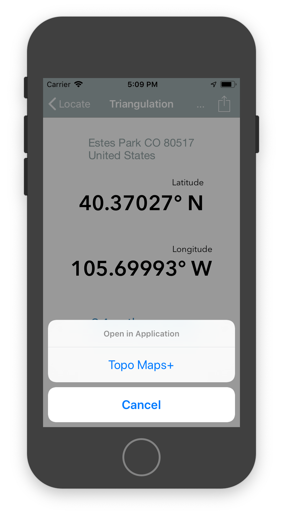

Field Triangulate:

I wrote this for wildland firefighting (locating smoke columns in the mountains) but a number of wildlife biologists use it for radio telemetry triangulations. Take two points plus compass bearings to a destination point and it calculates the latitude/longitude estimate for that point: iOS and Android, and free on IOS for the month, on Android for the next week: 

 https://www.neukadye.com/mobile-applications/field-triangulate/

Android Triangulation and PI

Performing triangulation calculations involves more than a little interaction with PI. Amusing that the Google Play Store rating might come out as PI … 🙂

Rating: 3.14 ≈ PI (3.14159…)

That said, more seriously … some old one star ratings are dragging things down a little. Old ratings that have not been updated when the application has been improved. New features of using the device compass to allow the application to get a bearing, offline support, persistent database, multiple events. Hopefully the application is higher than a three…

If you have the application and find value in it, a rating / review would be greatly appreciated.

Persistence in Android Field Triangulate

Android Field Triangulate has historically stored events (collections of readings comprising a triangulation) in memory. The intention was to create a few readings (in a relatively limited timeframe) and create a triangulation. Job done, triangulation shared. In actuality this isn’t how things always work, and wasn’t always sufficiently reliable.

Despite attempts to save these readings to instance state, in memory storage could lead to lost data … say if the application is unloaded (e.g. by a battery saver killing applications.) Lost data is never good, and this was never the intention.

Android Field Triangulate 1.3 now utilizes a persistent database in order to store readings. Sign up for a Beta Testing version, if you are interested in checking it out.

Setup persistent storage

Note: The reason for network connectivity at first setup is because the persistent store utilized is a cloud synchronized database. In theory (given a named account) this could be used to synchronize events (readings and triangulations) between devices. Please contact me if that seems of interest.


BTW: If/when asked for location permissions, Android Field Triangulate doesn’t need more than “Allow only while using the app”.

No background locations needed.

Response Utilities – Create Incident

Many response teams work in remote locations where mobile networks are not available, or are available sporadically. Being able to create an incident offline (a placeholder, if not full details) allows capturing incident attendance.

Response Utilities version 1.0.8 has an option to create an incident, attach members (even offline) and queue that incident until on network and the information can be uploaded to D4H.

This ability is available for beta testing. Please check it out and provide feedback.

Note: This ability is (of course) dependent upon the user having the required permissions for their account in D4H.

New option to press “+” to create an incident.
Add title, reference identifier, a short description and attach attendance (from list of membership, available offline.)

Timestamped Field Notes 4.9 Configuration

Timestamped Field Notes has too many configuration options. I know that, and I should likely trim some, but there are a varied use cases for the application, and I’d like to support those which I can. Further, I know that most users don’t adjust (or even know about) the default configuration settings, and that likely reduces the value of features placed behind a configuration option. All true, but where we are today…

Some new options for Timestamped Field Notes 4.9:

  • Search enabled – allow text search into events and/or notes.
  • Notes Grouping – group notes by the hour, day, or more…
  • Event Grouping – group events by the hour, day, week, month…

I use the application to monitor raptors, observing Peregrine Falcons, Prairie Falcons and Golden Eagle in the Rocky Mountains. I go hike, observe and record, export the data to submit with my report and move on. I do group notes and events, just for easier visually scanning. I don’t need search, I don’t go back and look at past entries. I do not have search enabled.

Others do. Some people use the application to record events, as a log. For them search allows them to quickly answer questions of “when did X occur”, either which events contained this note, or even which notes contained that text.

Go to “Manage” / “Configure Application” to get to the application settings.

D4H API

The D4H API (Application Programmer Interface) is a powerful way to access and interoperate with your organization’s D4H data, and enhance your organization’s D4H usage of it with your own developments.

For example you can create your own mobile application for D4H (in additional to the D4H mobile applications, that use the API.) That, or you can craft your own simple scripts, e.g. to provide a custom quiz to your users via the whiteboard.

The simplest way to get started is:

A more flexible (but marked as experimental, and quite likely soon changing) approach is to implement a user “login”, to gather a token on demand. Note: This isn’t quite as simple as it first appears, it is two step not one. ( When we log in to D4H first with an account it is second our membership in an organization/team that we then use for most API calls, and some accounts are members of multiple teams. ) The authentication API grants an account token, and to call the main APIs one needs to use the account token to acquire a membership token from that account token. (The generated token above – from the team website – is already a membership token.)

Once you have a working token you can access most of the team data; and update some.

  • Activities (past and future)
  • Duty records
  • Member records
  • Groups
  • Equipment (and more)
  • Tasks
  • … and more

What do you want your D4H data to do?

You might want to create a simple an app or webpage to allow your membership to submit maintenance reports your way, or you might want to display call statistics or some recent incident information (or available tasks) on a display in your building. The D4H API allows you to decide what is important to you, and enhance D4H towards that goal. (I’d love to hear your thoughts and ideas. Let me know.)

Powerful, but still ‘Work In Progress’, I hope…

Much as the D4H API is very powerful, the API is incomplete in a few key areas: incident updating, qualifications, tags, custom fields, and more.

Hopefully those will be coming because without them activities can be created, but not updated in any way (not adding a location, a tag, a description, nothing.) This limits any field-based tools for incidents.

No access to qualifications means we cannot create our own qualification reminder systems, and qualifications (we have many tens for every member) are a key challenge for our membership.

Notes Collector – Cloud sync

Notes Collector is the same application as Timestamped Field Notes, but on a completely different infrastructure. Whereas Timestamped Field Notes allows you to capture data to a local (internal) database and then export it, Notes Collector’s database is automatically synchronized with the cloud, when online.

Why is this valuable? For a number of years users of Timestamped Field Notes have wanted to share notes across devices, and with Notes Collector a note added on one device will appear on all your others.

Further, backups are automatic and ongoing. No need to export to Google Drive, or other, to get it safely backed up.

Notes Collector is now available on iOS and Android.

Share Triangulation Android

After considering offline sharing (to offline capable maps) of the triangulation on iOS, I realized the same should be possible on Android.

The share coordinate button on the beta version of the Triangulation application, now offers a chooser to allow any installed applications that support the geo:{LATITUDE},{LONGITUDE} scheme to be opened to that location.

Please join the open beta for Field Triangulation and check it out…

Open triangulation in application…

Some application that support this scheme are:

Triangulation & Offline Maps

Be it a wild-land firefighter locating smoke or a wildlife biologist tracking subjects, or one of many other users, Field Triangulate is often used in the back country, away from cellular networks. Field Triangulate works offline (to accept locations and bearings and generate a triangulated location) but it cannot show maps offline. I often get asked about adding “offline maps” support to Field Triangulate, but that is not on the product development roadmap at this time.

Topo Maps+ from Glacier Peak Studios is an excellent offline topographic map solution for iOS (iPhone and iPad.) It provides access to a wide variety of offline downloadable maps, and offers GPS features.

Field Triangulate for iOS version 1.1.2 will allow a triangulation (latitude / longitude) to be sent to Topo Maps+ (even when fully offline) in order for Topo Maps+ to display the map for that location. Topo Maps+ will use the current map, and current zoom to present that location.

Use Topo Maps+ to survey the terrain at the location, and between you and that location.

Topo Maps+ will even allow you to use that triangulation as a waypoint, allowing you to easily navigate to it.

Do you use other Topo Mapping Apps?

Let me know what application you use for offline-capable topographic maps on Android devices, and I’ll look to integrating Field Triangulate to that on Android.

Field Triangulate launching Topo Maps+ on iOS

Incident “Credits”

Our annual membership requirements include training (across all disciplines), some safety requirements (e.g. mask fit testing) and 20% incident attendance. That 20% … 1 in 5 calls … can be hard on some responders. Calls drop at odd hours of the day or night irrespective of life, family and work schedules.

We offer “Incident Credits” as incentives / rewards for above and beyond shifts (Christmas & New Year shifts … one credit atop any calls), for critical conditions patrols in hot/dry summer months, and for other worthwhile causes.

To apply an incident credit:

  • Create an incident, allow D4H to set its unique identifier (we don’t typically use the CAD identifier, but we might add an “a” or “b” to the end of one to associate it with that incident, e.g. stayed overnight to monitor the fire.)
  • Tag the incident as “Incident Credit” (we create that tag)
  • Invite *only* those getting the credit (do NOT invite the rest of the team, hence a bonus for those present, and no negative for others not present)
  • Approve the incident as/when your process dictates.

D4H shows “percentage attendance” which mathematically is a numerator of “number of attended incidents” over a denominator of “number of invited incidents”. Adding an “incident credit” is technically not fully 1 incident attendance since it adds to both the numerator and the denominator, but it is a valuable credit (and close enough.)

D4H Incident Percentage in Reports…

We tag incident credits as such, mainly so we can pull them out from regular incidents to get accurate response numbers for (say) grant applications.

D4H does a good job of maintaining individual response numbers, and incident credits allow us to give credit while keeping things simple (the presented numbers correct) for the volunteer.